
Solution
GPS Tag, RFID-like GPS-based Solution
- Overview
- Simple RFID-like GPS-based solution for indoor
- Patented solution(Under development)
GPS Tag Conceptual Diagram
GPS Tag Service Example
- Features
Motive
- Needs a system which can know the location indoor
- Causes difficulties in business when using additional standard/equipment
- Tends to have a built-in GPS receiver essentially including smart phones
Objective
- To emit signals based on GPS signal standard in order for GPS receivers to figure out the location by emitting signals in the form which the GPS receiver can receive in areas where GPS signals is not possible or according to the needs
- To deliver additional information besides information on latitude and longitude in a simple GPS
GPS Tag/Receiver
- Uses information services related to specific location by applying RFID concept to GPS
- GPS Tag
- Installs areas where it needs location-related services
- Sends location and additional information in the form of GPS signals
- Has small output and is possible to reduce cost and make products small - GPS Receiver
- Receives location and additional information from GPS Tag in the form of GPS signals
- Is composed without additional components to existing GPS receivers
- Applicable by updating SW
Sending information
- Location-related information(A-restaurant, B-exhibition hall, C-department store, D-subway station, E-bus stop and etc.)
- Information on routes to access information relevant to the location
- Internet address, telephone number
- Noted information(New information alarm, issuing coupons, advertisement and etc)
GPS Tag-installed areas
- Areas relevant to businesses - event halls, restaurants, hotels, department stores, underground parking lots
- Areas relevant to security - schools, institutions, housing for the old
- Areas for emergency and common services - subway stations, bus stops, buildings
- Special areas - military facilities
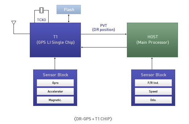
DR-GPS S/W, GPS fusion based on dead-reckoning
- Overview
Dead-Reckoning
-
This method is a dead reckoning sailing method which decides predetermined position by calculating predetermined direction and predetermined speed with the standard of random fixed position.
In order to calculate predetermined direction and predetermined speed, it uses an inertial sensor, an acceleration sensor and a geomagnetic sensor.
DR-GPS based Sensor
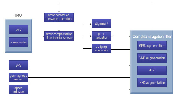
Pure navigation algorithm for DR-GPS
- Pure navigation algorithm
- Composite navigation algorithm
- Judging stop/operation algorithm
- Initial alignment algorithm
Sensor correction
- Zero-speed correction algorithm
- Conditional correction for limiting movement
- Speed indicator correction
- Correction during operation algorithm
- Features
DR-GPS Application with T1 chip